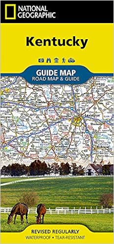
Expertly researched and loaded with helpful information, National Geographic's Kentucky Guide Map is a must-have for travelers exploring "The Bluegrass State." Cities and towns are easy to find with the map's helpful index. Highways, roadways, toll roads, scenic routes, and other roads are clearly designated. Distances in miles are noted on major highways so travelers can easily plan their best route. In addition to a state map, inset maps provide detail on the Covington, KY-Cincinnati, OH Area; Land Between the Lakes; Owensboro; Bowling Green; Frankfort, Louisville and Lexington.
Additional information and maps feature the recreation activities available in Mammoth Cave National Park and the attractions along the Kentucky Heartland scenic drive which stretches from Lexington to Harrodsburg. National and state parks, public campsites, visitor information centers, airports, ski areas, hospitals, and more are noted. A handy chart of park service sites and climate information are also included.
Every State Guide Map is printed on durable synthetic paper, making them waterproof, tear-resistant and tough — capable of withstanding the rigors of any kind of travel.
- Map Scale = 1:1,140,000
- Sheet Size = 24.75" x 17.75"
- Folded Size = 4" x 8.75"
![Grand Canyon West [Grand Canyon National Park] (National Geographic Trails Illustrated Map) (National Geographic Trails Illustrated Map, 263)](https://images-na.ssl-images-amazon.com/images/I/51sW7+IKcgS._SX228_BO1,204,203,200_.jpg)
![Mogollon Rim, Munds Mountain [Apache-Sitgreaves, Coconino, and Tonto National Forests] (National Geographic Trails Illustrated Map, 855)](https://images-na.ssl-images-amazon.com/images/I/51YuAk0rUmL._SX228_BO1,204,203,200_.jpg)
![Tonto National Forest [Map Pack Bundle] (National Geographic Trails Illustrated Map)](https://images-na.ssl-images-amazon.com/images/I/512U4aGOieL._SX220_BO1,204,203,200_.jpg)
Reviews (8)

Use to plan road trip
Good map but unfortunately I didn’t get to use it as our trip was cancelled. But it is printed on good quality paper and folds up compactly. Better than using iPhone because you can see entire state with details at one time! ....Easier to use for planning road trip!

As Advertised
Delivered on time and reasonably priced. Probably a bit more information than I need .. for sure.

Ok but not really what I wanted
Was looking for a map of red river Gorge but this only covers part of it

Waterproof!
nice!


